Shaping the Future of Coyote Valley
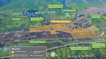
An aerial map of the Coyote Valley Conservation Areas Master Plan properties that have been protected by the Open Space Authority.
Tucked between San José and Morgan Hill lies picturesque Coyote Valley, one of the last undeveloped valley floors in the Bay Area. Working closely with our partners, the Open Space Authority is creating a master plan for habitat restoration, local agriculture, trails and new open space destinations on over 1,600 acres of protected lands in Coyote Valley.
These new ideas are being shared as the Coyote Valley Conservation Areas Master Plan “Concept Alternatives,” or design options, and illustrate a range of approaches for achieving the conservation goals for Coyote Valley on these lands. Learn more and see the proposed designs below!
Public Access & Agriculture Design Focus Areas
Through these restoration efforts, we want to connect you with even more nature! Four new open space destinations are being considered for the Coyote Valley landscape. For each location, a variety of options are being explored with a range of amenities and layouts. Not all the amenities shown may be built, so your input is critical to help us prioritize the available options. Take a look at the proposed destinations:
Laguna Seca Overlook
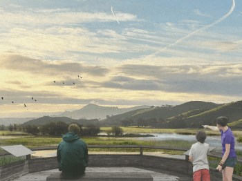
A rendering of the potential restoration of the Laguna Seca wetland includes an overlook of the wetland and rolling green hills and includes seating and interpretive signage.
The Laguna Seca Overlook would offer expansive views of the restored wetland in addition to educational or artistic interpretive features, seating, an observation platform and potential trail connections. A few different locations are being considered for this overlook.
See the locations and design plans for the Laguna Seca Overlook here.
Hill View Hub
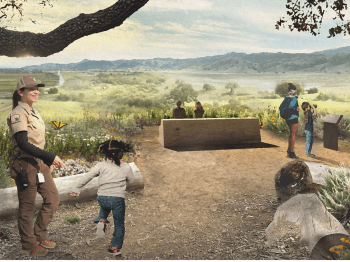
A rendering of the Hill View Hub shows people enjoying a natural, gathering space on the hilltop which includes seating, native plant restoration, interpretive signage and 360-degree views of the Fisher Creek floodplain and local agricultural lands.
On the southwest corner of Santa Teresa Boulevard and Bailey Avenue sits a beautiful hill that offers a half-mile spiral trail to its top and 360-degree views of Coyote Valley. The Open Space Authority plans to restore the hill and provide opportunities for the public to enjoy this unique property. The concept alternatives for the Hill View Hub include a gathering space on the hilltop, seating areas, native plant restoration, interpretive signage and 360-degree views of the Fisher Creek floodplain and local agricultural lands. A parking area, outdoor classroom, native plant nursery, and habitat restoration zones are also being considered in the flat areas just south of the hill.
Learn about the amenities being considered for this potential destination here.
Coyote Valley Field Station
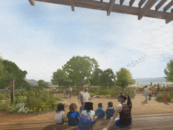
A rendering of the Coyote Valley Field Station shows people enjoying a native garden and seating next to the preserve.
The design plans for the “Coyote Valley Field Station” would expand Coyote Valley Open Space Preserve’s current amenities, including a welcome and education center next to the preserve, a multi-use trail connection to other parts of Coyote Valley and expanded parking to meet the additional demand expected with the addition of these proposed amenities.
Other ideas being contemplated for this location include a nature play area where families can explore and play using natural things like logs, rocks, and plants, a five-acre working farm that showcases climate and wildlife-friendly farming practices and a native plant nursery and a native plant garden.
Agricultural Gateway
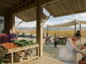
A rendering of the Agricultural Gateway shows people stopping at a farmstand to pick up produce and sit at picnic tables.
Agriculture is an important piece of Coyote Valley’s past, present and future. The Open Space Authority looks forward to supporting local farmers, farmworkers and ranchers with a new agricultural gateway at the intersection of Palm Avenue and Santa Teresa Boulevard.
The concept alternatives include a farmstand where people can buy produce from local farms, an educational space to learn about agriculture, trail access and seating areas. A farmer hub is also proposed with buildings and storage for farmers leasing and stewarding the Open Space Authority’s agricultural lands in Coyote Valley.
Take a look at the proposed options for this potential destination here.
Regional Trails & Connections
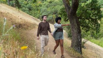
Two hikers walk along a nature trail surrounded by golden grass and a tree.
While one of the main priorities of the Coyote Valley Conservation Areas Master Plan is to create landscape linkages and habitat for wildlife, another goal is connecting people to nature. By strategically planning new trails that carefully avoid the most sensitive habitat areas, the Open Space Authority is committed to making nature accessible and enjoyable for all, while protecting nature.
In particular, the concept alternatives highlight how the Authority could work with partners to fill key gaps in the regional trail network with new trail segments that connect existing open space destinations in Coyote Valley, like Coyote Valley Open Space Preserve, with Santa Teresa County Park, Coyote Creek Parkway and the Bay Area Ridge Trail.
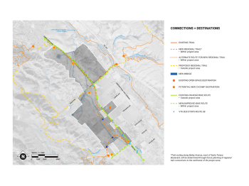
An aerial map of Coyote Valley details proposed nature trail and bike path options being considered for the future restoration of the region.
VTA Connections
Nature can be difficult to access. A car is often required to reach a park or preserve and, once you arrive, a parking spot isn’t guaranteed. The Open Space Authority is coordinating with the Valley Transportation Authority (VTA) to potentially design trailheads that are located next to existing bus stops that are improved with new shade structures, so visitors can easily hop off the local bus and enjoy nature in an instant.
Habitat & Floodplain Restoration Alternatives
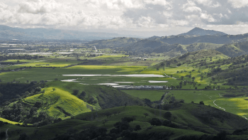
A photo of the Coyote Valley that showcases rolling, lush green hills and the Laguna Seca wetland.
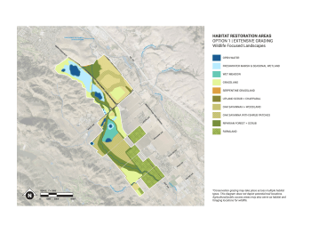
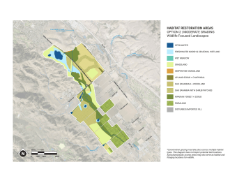
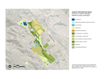
The Habitat and Floodplain Restoration Alternatives showcase three different ways in which the Open Space Authority can improve wildlife habitat, protect watersheds and reduce flooding by reshaping the land and waterways in the Laguna Seca wetland and along Fisher Creek—a manmade drainage channel created in the 1910s. The concept alternatives range from “limited grading” to “extensive grading,” in which grading refers to how much earth will be moved to protect, preserve and improve wildlife habitat.
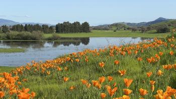
A photo of golden poppies abundantly growing next to the Laguna Seca Wetland.
All three alternatives propose the following actions that would greatly enhance wildlife habitat in Coyote Valley:
- Restoring Oak Savanna on Tulare Meadows, a valuable habitat for wildlife like bobcats and mountain lions who roam the landscape in search of food and shelter.
- Restoring the Laguna Seca wetland, an important habitat for birds migrating through the region and native amphibians, like the California tiger salamander and California red-legged frog.
- Realigning Fisher Creek north of Bailey Avenue to prevent flooding and provide a safer path for wildlife to access the creek.
- Restoring the Fisher Creek floodplain to create a more natural, ecologically rich mosaic of wetlands, ponds, oak savanna, grassland and riparian forests.
Extensive Grading Option
Moderate Grading Option
Limited Grading Option
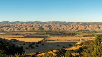
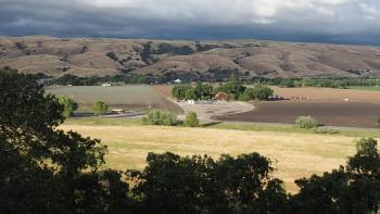
A photo of the Coyote Valley landscape with rolling golden hills in the background and agricultural fields in the foreground.
What Happens Next
Stay tuned as we continue to make headway on the next steps of the planning process. Over the next year, we’ll be working to mix and match the ideas in the concept alternatives into a preferred concept alternative and determining the best way to phase implementation of this plan.
Your feedback will help shape this preferred conceptual plan that will become the final Coyote Valley Conservation Areas Master Plan. TAKE OUR SURVEY to share your input on the future restoration of Coyote Valley.
Join the Open Space Authority for a series of FREE springtime family-friendly events in Santa Clara Valley that invite you to engage in nature-based activities and explore the beauty of Coyote Valley. At each event, the concept alternatives will be on display for the public to view and provide feedback. Click here to view a list of all Coyote Valley Discovery Days events!
Related Posts